
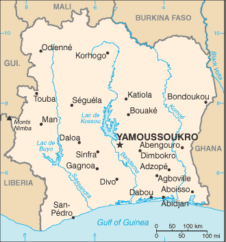
The Republic of Côte d’Ivoire, commonly known in English as Ivory Coast, is a sub-Saharan nation in southern West Africa.
The country is shaped like a square and borders the Gulf of Guinea on the north Atlantic Ocean to the south and five other African nations on the other three sides: Liberia to the southwest, Guinea to the northwest, Mali to the north-northwest, Burkina Faso to the north-northeast, and Ghana to the east. Its southern boundary is along the Gulf of Guinea.
The terrain is mostly flat to undulating plain, with mountains in the northwest. The lowest elevation in Ivory Coast is at sea level on the coasts. The highest elevation is Mount Nimba, at 1,752 metres in the far west of the country along the border with Guinea and Liberia.
Côte d’Ivoire’s political capital is Yamoussoukro, and its economic capital and largest city is the port city of Abidjan.