
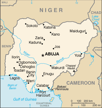
Nigeria, officially the Federal Republic of Nigeria, is a federal constitutional republic comprising 36 states and its Federal Capital Territory, Abuja.
The country is located in West Africa and shares land borders with the Republic of Benin in the west, Chad and Cameroon in the east, and Niger in the north. Its coast in the south lies on the Gulf of Guinea on the Atlantic Ocean. The name Nigeria was taken from the Niger River running through the country.
Noted geographical features in Nigeria include the Adamawa highlands, Mambilla Plateau, Jos Plateau, Obudu Plateau, the Niger River, River Benue and Niger Delta.
Nigeria is the most populous country in Africa, the eighth most populous country in the world, and the most populous country in the world in which the majority of the population is black.
The former British colony is one of the world’s largest oil producers.