 BAHAMAS
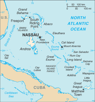
The Commonwealth of the Bahamas is a nation consisting of more than 3,000 islands, cays, and islets. It is located in the Atlantic Ocean north of Cuba and Hispaniola (Dominican Republic and Haiti), northwest of the Turks and Caicos Islands, and southeast of Florida. Its land area is 13,939 km2.
The closest island to the US is Bimini, which is also known as the gateway to The Bahamas. The largest island is Andros Island. Other inhabited islands include Eleuthera, Cat Island, Long Island, San Salvador Island, Acklins, Crooked Island, Exuma and Mayaguana. Nassau, capital city of The Bahamas, lies on the island of New Providence.
All the islands are low and flat, with ridges that usually rise no more than 15 to 20 m. The highest point in the country is Mount Alvernia (63 m) on Cat Island.
The Bahamas attracts millions of tourists each year. The visitors come to enjoy its mild climate, fine beaches and beautiful forests. The country is a major centre for offshore finance and has one of the world’s largest open-registry shipping fleets.