
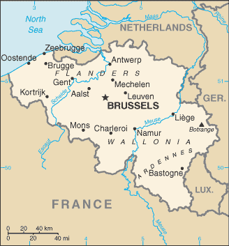
Belgium is a sovereign state located in Western Europe, bordering the North Sea. Belgium shares borders with France (620 km), Germany (167 km), Luxembourg (148 km) and the Netherlands (450 km).
Belgium comprises the regions of Flanders, Wallonia and Brussels.
The name ‘Belgium’ is derived from Gallia Belgica, a Roman province in the northernmost part of Gaul that was inhabited by the Belgae, a mix of Celtic and Germanic peoples.
Today, Belgium is divided into three regions and three communities, that exist next to each other. Its two largest regions are the Dutch-speaking region of Flanders in the north and the French-speaking southern region of Wallonia. The Brussels-Capital Region, officially bilingual, is a mostly French-speaking enclave within the Flemish Region.
Belgium’s linguistic diversity and related political conflicts are reflected in its political history and complex system of governance, made up of six different governments.